
|
Download
Navigation
Project submissions
Forums
Mail Lists
|
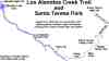 |
SBAY Geek Ride routes
(by Ian Kluft)
|
| Bike map to Linux10 picnic, part of the Linux10 directions at linux10.org (by Ian Kluft) | |
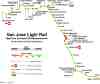 |
VTA Light Rail GPS Map, San Jose, California (by Ian Kluft and Gary Haussmann) |
|
Flight track
from San Jose to Raleigh-Durham
(by Ian Kluft)
Note: this data was collected in November 2000, with permission of the airline. After the changes since Sept 2001, it is even more important to check with the crew before putting a GPS antenna on the window. |
|
 |
Map of a route back from a desert camping trip to Silicon Valley. The trip was to Nevada's Black Rock Desert. |