
|
Download
Navigation
Project submissions
Forums
Mail Lists
|
Currently this only supports GPS models by Garmin. Use the gpstrans program (another project hosted on SourceForge) to download the track from your GPS. However, enhancements to support other hardware will be accepted.
Generating a map image is done as follows:
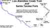 See some example images which have been created
with rideplot.
The related links page lists other software that
you'll need to get rideplot working.
See some example images which have been created
with rideplot.
The related links page lists other software that
you'll need to get rideplot working.
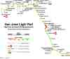 This map of the light rail system in San Jose
drawn with RidePlot
has gotten quite a bit of attention recently.
It was highlighted on the web site of the
VTA Riders Union,
a transit advocacy group in Silicon Valley.
It was also mentioned in the
Nov 29, 2001 "Public Eye"
column of the
Silicon Valley Metro
weekly newspaper.
This map of the light rail system in San Jose
drawn with RidePlot
has gotten quite a bit of attention recently.
It was highlighted on the web site of the
VTA Riders Union,
a transit advocacy group in Silicon Valley.
It was also mentioned in the
Nov 29, 2001 "Public Eye"
column of the
Silicon Valley Metro
weekly newspaper.
See the slides from the
GPS Ride Plot Project presentation at SacLUG
in Sacramento, California on Nov 14, 2001.